


who can refuse through this beautiful path. Who can shake his head to walk between two hills covered with savanna and edelweiss. Who also does not want to watch the waterfall on the right left. Aaaah Torean ,,, !! You are not as scary as others say. Stay silent, still quiet. In order for your beauty can be enjoyed intact.
I've been climbing Mount Rinjani peak whose height reaches 3,762 meters above sea level. Rinjani is the second highest volcano in Indonesia, so it will be a pride if it can perched on top.
Rinjani is located on the island of Lombok many claimed as a mountain with the most beautiful scenery. How come? Because Mount Rinjani is a one stop service mountain, complete. There is a savanna, there is a jungle, there are waterfalls, hot water, fish, etc.


Speaking of the beauty of Rinjani, I will tell my experience down the mountain through the Torean track. Why why down, why not be told up? Well if the affairs up the same heck actually wrote. Me and seven other friends as well as one porter through the path Sembalun. The path chosen by the climbers in general. The stories are the same, through the savannas, enter the post 3 extra, nanjak in the hill of regret, make camp in plawangan Sembalun, first clay lake Segara child, leaving the night until the peak, continue the photographs, hehehe.
WE CHOOSE TOREAN ROAD !!!
Well to go down, if usually people will choose Senaru Line, we try through Torean Line. Where is Torean's line?
Torean is the name of one of the places in Kecamatan Bayan, North Lombok regency. Torean line is between two hills of Plawangan Sembalun and Pelawangan Senaru (Gunung Sangkareang). Wuiiiiih cool dong flanked by two hills so?
YESSSSS, VERY-VERY COOL.

This is what makes us pass through the Torean line. So far, Torean is known as the traditional route of Lombok Utara community to reach Segara Anak Rinjani Lake. This path is also often bypassed by Hindu Lombok people to perform the ceremony Mulang Pekelem in Lake Segara child.

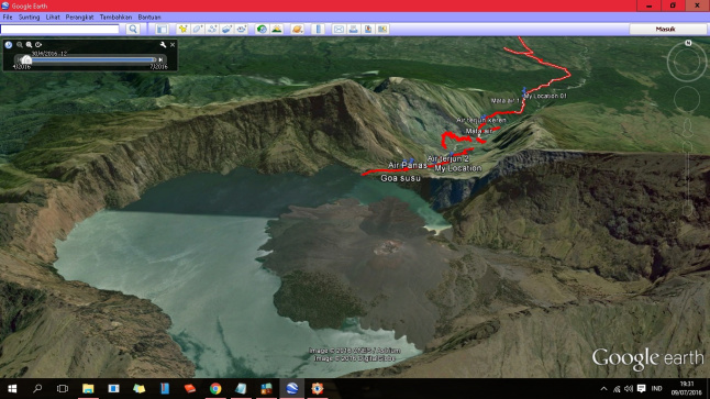
The entrance point of the Torean lane is located near Segara Anak Lake rather leaning towards Plawangan Sembalun. Notice the branching to the north that does look vague because it is blocked by tall grass. Anyone should be careful because there are so many tissue scattered and 'land mines' aka human climbers who think this path is the path to the natural toilets.
A few hundred yards later, the cool scenery of the two giant hills covered with savannas we could see. The Torean line is right between the two. Just like the giant wind gate, the fog often flies beautiful in this valley.

The journey was even more challenging. Ahead of Goa Milk we got wrong path. In the branch that also looks faint from the bushes, we chose the straight line which is the top of Goa Milk. Though the right path is turn right then down to the bottom. Below is already available a very warm water pool pamper body. This warm pool comes from Goa Milk. Actually straight can be, but rather extreme, because it is a shortcut to Goa Milk. Goa Milk is a cave that is at once a hot waterfall. Cool, right? (Coordinate Goa Milk S8 23,312 E116 25,499)


After quite relaxed, we continue the journey again. The beauty of Mount Rinjani more and more. Despite being treated by incredibly cool natural scenery it must remain vigilant with the abyss. The phrase "Anjeeeeeeer cool bangeeet" is always accompanied by the cry "Be careful guys, next to the abyss"

On the left side, we saw a waterfall high enough with water debit that is not too much. The first waterfall we met was called Pancor Mas. This waterfall is quite far from the path so it looks very thin. The viewing position of Pancor Mas waterfall is in Coordinate S8 23,089 E116 25,771.

Furthermore, the terrain of the Torean is increasingly extreme. At one point, we passed a road that was not up to one meter wide on the left side of the ravine with a depth of about 20 meters. We have to be careful, let alone the stones we stand on are not so stable. Luckily there are plants that we can make as a handle.

Not far from the ravine we came back to meet with a rather mild waterfall. This waterfall is known as Aik Genit. Characteristic of this waterfall is a dark colored water pipe that hangs on it.

After walking down the hill to the east of Plawangan Sembalun alias, we crossed the White Kokok River and turned down the hill to the west. Sungai Kokok Putih is located in Segara Anak. The river is quite clear with a white base, orange to brown due to a mixture of sulfur. For people who are downstream of the river, the color change, aroma, and debris of the White River Kokok made a sign of volcanic activity of Mount Rinjani. At the end of 2015, when Mount Baru Jari in Rinjani erupted, the crowding of white crows grew stronger, cloudy and smelled of sulfur. The community was forbidden to consume river water including the fish that live in it.


Haaaa, the condition of the path is increasingly crazy, in the form of savanna hills with cliffs that faithfully accompany. The path that runs along the edge of the hill is not much, while the right side of the cliff. The presence of a rather tall grass made us feel comfortable. The fog was getting thick, and the White Kokok River far below was less visible. With the fog, we kept walking very carefully. Slowly the fog began to unfold, blowing in the wind. Overhanging a steep green hill appears standing in front of the eye. White River Kokok which is white began to appear, as if giving a "gesture in front of you abyss in lhoooo"


Day began the afternoon, we finally found a patch of flat land used as a place to set up a tent.

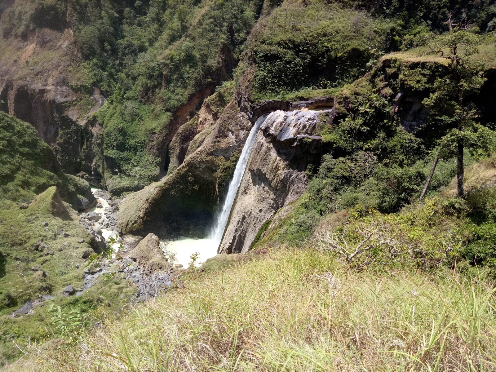
In the morning we immediately rushed off, after cooking for breakfast, we set out to arrive at the destination not too late. Not far from where we set up a tent, we found a super kece waterfall that became an icon of Torean path, Waterfall Penimbungan. This waterfall is under the path with heavy flow and deep enough.

After Waterfall Penimbungan, we have entered a fairly shady vegetation. The road conditions are not too steep. We met some fallen trees and blocked the road. Residential areas began to be characterized by a corn field owned by residents.


Source :
Access Date, 15 March 2018
https://tengakarta.wordpress.com/2016/07/09/menuruni-gunung-rinjani-melalui-jalur-torean/


0 komentar:
Posting Komentar